Saturday, January 2, 2010Going For A Little Drive
Total time ~6 hr
170 mi total driving
~0.5 mi hiking/climbing
I have a suspicion that if I invited you to "go for a little drive to see the area" while my friends were standing behind me, they would give you a look of alarm and shake their heads violently while mouthing "No!" to you with great exaggeration. I've probably earned this reputation; riding with me is not for the faint-hearted. When I say we've driven Big Blue all over God's creation, I'm not kidding...we often see the dumbfounded looks on 4-wheel-drivers wondering how in the blazes we got where we've met--in a Chevy van! (They should see where I used to take my little Japanese cars!)
Unfortunately, there was no such Greek chorus to warn my German friend when she emailed on New Year's day, asking if I wanted to do anything Saturday. I said I wanted to go for a little drive, to do some recon on a trailhead. Now, this is the same friend that survived riding with us over the heights of the 3N17 -- the same road off which the firefighters killed in the Station fire last August plummeted 800 feet. I still remember the first time I explored 3N17 -- alone and without cell service. I wondered how hairy it would get while I was driving it; but once I did it, I've been back without worry (although keeping a tight grip on the wheel).
Well, this "highway" made the 3N17 seem a bit tame. Oh, we were still dealing with a narrow dirt road at an incredible angle climbing high with no guard rails and massive exposure in the guise of views, just like the 3N17. But for starters, we ignored the "Road Closed" sign on this one (it just looked wrong). Click on each photograph to see larger version.
 The "highway" immediately starts climbing once it becomes dirt.
We had barely gone one mile when we found a place to pull over and take a break and decide if we really should continue on this "road." A vandalized platform provided us with an excellent view of the dam below us, the canyon east of us, and the mountain range to the southwest.
 Capturing the view.
 Panostitch of the view...it really doesn't do it justice, but you can get an idea!
So of course we were grinning the whole time!
It took us an hour and 45 minutes to reach the trailhead; we found it without a single hitch as far as directions go (if you don't mind the road conditions!). We parked and started down the trail, seeing if it would be suitable for mountain biking, hiking, or climbing. We rounded a hill and dropped down into a canyon. Clearly not suitable for the mountain bikes. We could see a long loop around the end of the canyon and the trail climbing on the opposite side above us. This is a trail we plan to try another day; and no matter the temptation, not enough daylight was left to take it on today. So we made the decision to turn back there, even though we had barely started hiking, because all we'd really planned to do anyway was go for a little drive.
As we headed back, we could hear running water that we had heard earlier but never saw before the sound faded. I asked my friend if she wanted to explore the source of the sound. Of course, she was game. The canyon was too steep to scramble down there, so we went back to where the trail crosses a currently dry runoff descending into the canyon.
We climbed down the rocks into the canyon and saw one little standing pool of water just above where the runoff bed we were following intersects with a larger creekbed. The sound was louder here; clearly it was falling water since there wasn't enough water to be a rushing creek.
We climbed up the boulders of the mostly dry creekbed to where a waterfall--or a tricklefall, as my friend called it--descends through a crack in a huge slab rock wall and ends in a little sandy pool. What a lot of noise from a trickle of water!
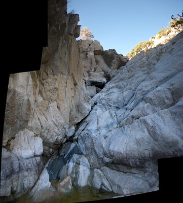 Scissors might not, but water conquers rock!
Moss was on some of the rocks around us. I touched it; it didn't even feel damp. It was so soft, and thick; like a very spongy velvet. Beautiful!
 Spongy, velvety, bright green moss in the surrounding rocks.
As I sat snapping my pictures, my eye kept returning to a ledge across from us. "Hey, why don't you get up there and I'll take your picture there?" I told my friend. "Just don't fall in." We both grinned. Not like that's ever happened, huh!
 A nice little ledge across from me.
She navigated the rocks successfully and tucked her long limbs into the hidey-hole. I snapped a few pictures with her new camera. "Your turn!" she told me. Yeah, turnabout is fair play. Let's see if I can climb up there without falling in!
Well, I did! But at one point, I had to lunge and pulled a muscle in the top of my leg. OUCH! My muscles are so tight.
By now, the sun was disappearing behind the moutains, taking with it our warmth against the chilly winter air. And since we had really only planned on going for a little drive, we figured it was time to get started back. Of course, now we have to climb UP that steep runoff bed!
 Bidding farewell to our little tricklefall and pool.
Water conquers rock!
After taking our farewell shots, we climbed back down the streambed. I passed one rock that had green mineral in it; it was soft like soapstone but bright like actonite. Pretty stuff.
We crossed by the still pool and headed up the runoff bank. Wow, too bad I didn't bring my poles! I was grabbing onto every rock and plant I could find to pull myself up the bank. It was quite a steep climb that worked up a sweat and left me gasping to catch my breath. My poor legs complained how tight the muscles were, forcing me to stop every 10 feet or so as we slowly made our way out of the canyon.
Once we reached the trail, it was a piece of cake back to the trailhead; and Big Blue was waiting for us, undisturbed. Since we had really only planned on going for a little drive, we tried to make calls. Still no cell service. We decided to take the pavement home, even though it was a longer route -- best to not risk getting stuck on that dirt highway in the cold night air!
So now we were winding through the mountains, with the sinking sun constantly blinding us as we worked our way to lower elevations on the narrow, hairpin-curved road. It's just always an adventure, even doing something as simple as going for a drive!
By now, we were starving. Since we were only going for a little drive, we hadn't packed any trail food beyond some nuts and dried fruit. We ate those as we headed toward home, looking for a place to stop and eat along the way. There really wasn't any place! We finally stopped at Mountain Top cafe, where I enjoyed some excellent fried chicken. It was dark by the time we left there; but it only added 45 minutes to our day and at least dinner was dealt with! When we got home, we collapsed.
The next day, when I awoke, I couldn't figure out why I hurt so much and could barely walk. Then I remembered all those rocks and that one particular lunge. Even as I write this, I am still hurting! Guess I'm getting old. But then, that's a good thing!
 From the vista point.
 Southern rocks.
 Starting down the trail.
 The round rock (trail above).
 From the trail.
 Our summertime waterslide.
 Manzanita bush.
 Creekbed below the Witch and the Devil.
 My guys on the ledge above me.
 OK, back to the trail.