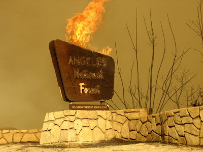
In the meanwhile, we are still unable to do any hiking in our "backyard." Officials had hoped the Station Fire would be 100% contained (and out) by now, but that is not to be the case. The last 2% to be contained is in area so dense and rugged that it can't be contained and put out -- nature will have to do it with rainfall.
So the forest remains closed. Much of the San Gabriel Mountains, featured in so many blog posts here this year, is now burned up. Mt. Baden-Powell and East Blue Ridge escaped the flames but are still closed, as is Big Rock Creek and Devil's Punchbowl.
Highway 2 (Angeles Crest Hwy) and Angeles Forest Hwy both remain closed and are expected to remain so for quite awhile. CalTrans presently estimates 5 wks to replace burnt guard rail posts, guard rails, and burnt signs. And they can't even start till the fire is OUT 100%!
I spoke to Ranger Jonathan from Devil's Punchbowl, and he says the fire did not reach the Burkhart trail, which means Buckhorn probably did not burn. So that will still be nice next spring, in addition to East Blue Ridge, for wildflowers.
Here is a post from a volunteer wilderness ranger. Click on the link for photos.
"The forest closure will be in effect more than likely until November. I know first hand every thing from Big Pines to La Canada is closed and will remain closed until the fire is OUT!! NOT A DAY SOONER!! Then there will be all the work Cal-Trans will have to do replacing the miles & miles of guard rails burnt out and clearing the highway of all the rocks and debris. The current plan the Forest Service is going with is to keep the forest closed to all until spring 2010.
It's bad but what's worse, you have no idea how bad until you see photos. From Big Tujunga all the way east to Rincon/Shortcut. The mountain has nothing on it. Oh there may be a pocket of green here then way over there but for the most part, kiss this forest goodbye for 10 years. Yes, really. Every guard rail is burnt out, Road signs are literally melted. Animals burnt on the highway. Burn holes on the highway surface as well. In a lot of locations only one lane of the highway is there, the other half is covered in rock slides and debris.
I have never been to the moon but this can't be far from it.
The Arroyo is a total burn out, nothing green in the canyon from La Canada to Switzers & then to Red Box. The Pines picnic area that burnt late last year has trees there still green. Some area recesses have trees, but anything exposed is gone."
===========================
Pictures of the aftermath:
http://www.3fbikeclub.com/


No comments:
Post a Comment